


Willisville, a small Nevada County town, is adding fiber internet safety with a GIS-first approach. Before a single trench was dug, local leaders worked with Communities Unlimited (CU) to map the town’s underground utilities, focusing especially on water lines that could be damaged during fiber installation. The effort, part of the USDA-supported Broadband Technical Assistance (BTA) program, aims to minimize outages and delays while building a durable data layer for the community’s infrastructure future.
The mapping project unfolded within a larger context: CU’s two-year BTA initiative, running from 2025 through 2027, supports rural communities as they plan broadband expansions. Willisville joined a regional network coordinated by the Nevada County Broadband Committee, which includes nearby towns like Prescott and Rosston. CU’s technical staff, led by Katy Parrish and Ali Milligan, helped town officials understand the technical steps needed to prepare for fiber and laid the groundwork for safer, faster construction.
“Everything just started rolling along smoothly,” said Christy Burney, Willisville’s mayor, after the initial planning phase helped align community needs with BEAD- and BTA-backed activities.
A critical early decision centered on Willisville’s water system. Mayor Burney flagged questions about water-line locations, and CU’s GIS team was called in to map the underground network. Without accurate utility data, fiber crews risked damaging water lines, which could trigger service outages and costly repairs while delaying construction. The mapping effort would also support long-term operations, giving the town a reliable, up-to-date digital model of its water infrastructure for future maintenance and planning.
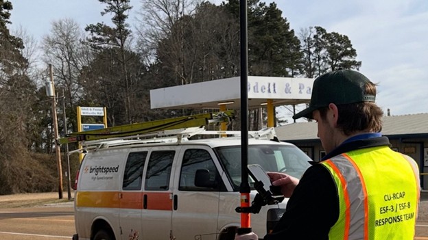
In January 2026, Willisville requested GIS mapping help, and the town’s water system—long past its prime of decades-old blueprints—needed a comprehensive update. GIS specialist Harrison Brown arrived on February 24 and began a field-and-desk mapping process that paired the mayor and CU staff with real-world data collection. Using multi-band GNSS gear mounted on surveying poles and real-time kinematic (RTK) corrections delivered via a web-based system, Brown captured water-line locations with centimeter-level precision and verified which side of each street the lines ran along. The result: a detailed digital map and wall maps that contractors could use on the ground before digging begins.
Inside three field days, Brown produced the finished GIS dataset and accompanying maps, and Willisville’s broadband contractor took delivery of the data just before construction started on March 2. Local officials reported that the contractor could begin excavation with confidence, greatly reducing the risk of water-line hits and service disruptions. Mayor Burney observed that the speed of the GIS work helped keep the fiber project on track, noting that the contractor received the maps within an hour of being shown how to use them.
As Willisville moves toward completion of the fiber rollout, estimates suggest mid-March as the target finish. For residents who previously faced limited internet access—some traveling long distances to libraries or schools—the new connection is a major milestone. Willisville’s mayor highlighted how the combination of fiber connectivity and robust GIS data will benefit the town long after crews depart, ensuring that water lines, valves, and hydrants remain well-documented for future administrators. The GIS maps, wall charts, and on-site field maps will continue to guide future maintenance and rapid response if infrastructure changes occur.
Get this news in your inbox. Subscribe to the Broadband Communities newsletter to stay informed about rural broadband developments and mapping best practices.